3 What are the pressures?
The 2011 Australian state of the environment report (State of the Environment 2011 Committee 2011) identifies the following pressures on Australia’s biodiversity:
- fragmentation of habitat
- climate change
- land-use change
- invasive species and pathogens
- grazing pressure
- altered fire regimes
- changed hydrology.
The most frequently cited threats in listings under the EPBC Act and resulting recovery plans are habitat fragmentation and the spread of invasive species.
There is also increasing recognition that climate change is having, and will continue to have, a significant impact on Australia’s biodiversity (Prober and Dunlop 2011). Climate change will impact species and ecological communities both directly and by exacerbating existing stresses or pressures such as fragmentation, introduced species, overharvesting, modification of the hydrological cycle and changed fire regimes (Prowse and Brooks 2010). It remains difficult to predict impacts accurately, but plants and animals are likely to experience shifts or changes in genetic composition, geographic ranges, lifecycles and population dynamics (Steffen et al. 2009).
3.1 Pressures on native vegetation
In South Australia, the extent of native vegetation has been greatly reduced in temperate parts of the state (see Section 2.1.1) and in many areas its condition (see Section 2.1.2) has declined since the time of European colonisation. Native vegetation remains subject to a number of pressures that can lead to further degradation.
3.1.1 Clearing and fragmentation
Vegetation is no longer cleared to the extent that this occurred in the past, but continued degradation of remaining native vegetation cover contributes to ongoing fragmentation and incremental changes (Forman 1995). Fragmentation tends to exacerbate the impacts of other threatening processes by reducing the area of remnant patches of native vegetation and increasing the exposure of the edges of these remnant patches to invasions from pest plants, animals and pathogens (Lindenmayer and Fischer 2006).
3.1.2 Fire
Fire plays an important role in shaping Australia’s biodiversity and is a factor that influences the composition, structure and function of native vegetation. Inappropriate fire regimes can lead to major changes in the structure of ecological communities and increase the risk of extinctions. As a result of climate change, fires are likely to be larger and more frequent (Driscoll et al. 2010) because of more frequent and prolonged droughts (Pittock 2009).
Prescribed burns are an important management tool used by South Australian Government agencies (Department of Environment, Water and Natural Resources [DEWNR]; Forestry South Australia; South Australian Water) to reduce the risks that fire poses to human assets, as well as for ecological outcomes such as regenerating fire-dependent plants. There are many uncertainties about how to use fire to meet conservation goals, and existing programs throughout Australia have insufficient data to determine if they are being implemented successfully (Penman et al. 2011). This is the case for both vegetation and wildlife management because the response of a range of species to fire remains poorly understood and documented (Clarke 2008, Driscoll et al. 2010).
3.1.3 Other pressures on vegetation
A number of other pressures that impact native vegetation were identified in the 2008 state of the environment report for South Australia. These pressures remain, and include:
- stock grazing—trampling of plants, browsing of adults and seedlings, weed dispersal and disruption of native plant recruitment
- senescence (ageing and deterioration) of adult plants and low rates of seedling recruitment, symptomatic of land cleared for agriculture and other purposes
- pest animal, plant and pathogen invasions—displacement of native species, disruption of lifecycles and ecosystem processes, and degradation of habitat quality
- dryland salinity, which impacts productive land and native vegetation; of 300 000 hectares affected by dryland salinity in 2008, 18 000 were native vegetation and 45 000 were classified as wetlands
- direct human impacts such as trampling and vehicle movement, soil compaction, destruction and disturbance of vegetation, and illegal firewood collection.
3.2 Land management and effects on soil
Approximately 10.4 million hectares of cleared land are used for agriculture in South Australia. Most of the land in the state has been changed through grazing, cropping, and the application of fertilisers, herbicides and pesticides. Changes in the soil as a result of these land uses affect biodiversity primarily by affecting vegetation.
Figure 3 shows a conceptual model of soil processes and pressures.
3.2.1 Soil erosion
Erosion is a natural process; however, the clearance and cultivation of land for agriculture has resulted in rates of soil loss that are many times higher than in undisturbed environments. Soil erosion is the highest priority threat to the agricultural soils in South Australia. Approximately 6 million hectares of agricultural land (58% of cleared land) are inherently susceptible to wind erosion, and 3.2 million hectares (31%) are inherently susceptible to water erosion (Soil and Land Program 2007ab). The magnitude of this threat is recognised in Target 70 of South Australia’s Strategic Plan: Sustainable land management (Government of South Australia 2011).
Without intervention, soil erosion can have adverse social, economic and environmental impacts. Soil erosion depletes the productive capacity of land as it removes nutrients, organic matter and clay from soil, which are most important for plant growth. Soil erosion also has a wide range of costly offsite impacts, including damage to roads; disruption to transport and electricity supply; contamination of wetlands, watercourses and marine environments; and human health impacts caused by raised dust.
Soil is predisposed to a risk of erosion by physical disturbance or removal of surface vegetative cover. Very dry seasonal conditions increase the risk of erosion where there is reduced vegetative cover resulting from poor crop and pasture growth.
Grey-box forest, Mt Lofty
Barbara Hardy Institute
-01_fmt.jpeg)
Figure 3 Conceptual model of soil processes and pressures
The critical management practices that affect the risk of soil erosion are:
- the occurrence, intensity and timing of tillage operations
- the quantity and nature of surface cover.
Most of the erosion risk is due to cropping practices such as tillage and stubble burning. Grazing management is also an important factor, especially in dry years and droughts. The highest risks associated with grazing occur in late summer and autumn, when feed availability and the cover of annual crop and pasture residues is declining.
Soil erosion has steadily declined in the agricultural areas of South Australia over the past 70 years because of improvements in farming practices, but soil losses still occur with extreme wind or rainfall events, and after severe or prolonged drought.
Soil erosion is difficult to measure directly because its occurrence is highly sporadic. Instead, the protection of soil from the risk of erosion is monitored, because any trend in the risk would result in a matching trend in actual erosion in the long term. The DEWNR has used observational field surveys to assess the protection of agricultural cropping land from erosion since 1999. Telephone surveys of agricultural land managers are also conducted to assess trends in land managers’ knowledge of, and attitudes towards, soil management issues, and the land management practices they use. These trends provide quantitative evidence of practice change that can explain observed changes in erosion protection.
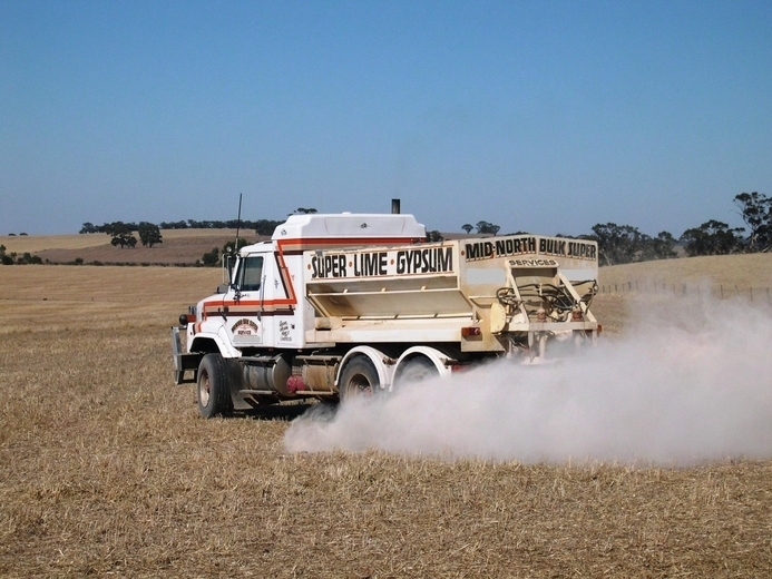
Spreading lime
Tim Herrmann
Soil protection is expressed as the average number of days per year that agricultural cropping land is adequately protected from erosion. There has been an overall upward trend in soil protection over the last 10 years, despite several years of drought and other challenging management issues (Figure 4). South Australia’s Strategic Plan 2011 has a target to achieve a 25% increase in South Australia’s agricultural cropping land that is adequately protected from erosion by 2020, from the 2003 baseline. The target requires an increase from 272 days of protection in 2002 to 340 days in 2020. From 2003 to 2011 there was a 21% increase, from 272 to 328 days.
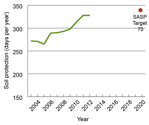
Figure 4 Trend in the average annual period of protection of agricultural cropping land from soil erosion in South Australia,2002–12 (days soil protection per year, 3-year rolling mean
Source: DEWNR (2011)
The adoption of more sustainable land management practices, such as no-till sowing and stubble retention, has improved the protection of soil from erosion. No-till sowing involves sowing the seed in a narrow slot in the soil to minimise soil disturbance and maximise residue protection on the soil surface.
Telephone surveys show that the proportion of crop area sown using no-till methods has increased from 16% in 2000 to 66% in 2011 (Figure 5). This trend has occurred in all the major cropping regions. There has also been a corresponding reduction in the use of tillage and stubble burning before sowing the crop. The trend in adoption of no-till sowing is levelling off, and this may limit further improvement in erosion protection.
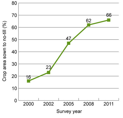
Figure 5 Change in the proportion (%) of crop area sown using no-till sowing methods in South Australia, 2000–11
Source: DEWNR (2011)
The use of clay spreading and delving to manage water-repellent soil is becoming a factor in the protection of soils from wind erosion. These techniques are widely used in the Southern Mallee and upper South East areas, where there are large areas of severely water-repellent soils. Clay spreading and delving increases the clay content of the surface soil, improving soil strength and resistance to erosion. Crop and pasture production is also increased, providing higher levels of plant cover to protect the soil from erosion. Confinement feeding allows stock to be removed from paddocks before surface cover declines below critical protective levels. It is a very important technique for preventing erosion during droughts and in late summer and autumn when ground cover declines.
3.2.2 Soil acidity
After erosion, soil acidity is the second highest priority threat to the sustainable management of agricultural soils in South Australia. Approximately 1.9 million hectares of agricultural land (20%) are affected by soil acidity (Soil and Land Program 2007ab). Many soils in the higher rainfall areas of the state are naturally acidic. Soil acidification can be accelerated by agricultural practices including removal of grain, hay and livestock products from the paddock, use of ammonium-containing or ammonium-forming fertilisers, and leaching of nitrogen derived from legume plants or fertilisers. Sandy-textured soils and higher levels of production also tend to lead to higher acidification rates.
The consequences of untreated highly acidic soils include:
- reduced growth and production of most agricultural plants
- increased soil salinity due to increased drainage of rainfall to groundwater
- increased leaching of iron, aluminium and some nutrients, leading to contamination of surface and groundwater
- structural breakdown of the soil.
Surface soil acidity can be readily treated by applying liming products. Acidity can also be ameliorated by incorporating calcareous or alkaline clay, or using alkaline irrigation water. The use of deeper rooted perennial plants and effective management of soil nitrogen can reduce the rate of acidification. However, subsurface acidity (below 10 cm depth) is more difficult and expensive to treat. If acidic topsoils are not adequately treated, there is an increased risk of subsurface acidification.
The DEWNR has monitored the amount of lime sold annually in the agricultural regions of South Australia since 1999. This provides an indirect measure of the extent to which farmers have both recognised and addressed the soil acidification problem.
Lime use in the state rose through the late 1990s but then declined through the early 2000s, and has been relatively steady since 2007–08 (Figure 6). The estimated amount of lime required to balance the annual acidification rate in the agricultural zone of South Australia is approximately 213 000 tonnes. The average amount of lime applied per year over this period was approximately 113 000 tonnes—only 53% of that required to balance acidification. There are still large areas of land where acidification continues to damaging levels. The DEWNR land manager surveys indicate that there is inconsistency in land managers’ understanding and awareness of soil acidity in acid-prone areas. Despite the relatively low cost of lime in South Australia compared with other states, farmers often cite cost as a key barrier to its use.
-01_fmt.jpeg)
EP = Eyre Penisula; NY = Northern and Yorke; AMLR = Adelaide and Mount Lofty Ranges; KI = Kangaroo Island; SAMDB = South Australian Murray–Darling Basin; SE = South East
Note: Regional lime sales data is approximate because of difficulties in delineating lime sales between regions.
Figure 6 Estimates of the amount of lime sold from 1998–99 to 2010–11 by natural resource management region, and total for South Australia
Lime also needs to be applied to raise the pH of soils that are already acidic. An estimated additional 1.1 million tonnes of lime is required to treat topsoils that are already acidic (DEWNR 2011).
Soil acidification is becoming an increasing issue in cropping districts due to high levels of production and increased use of nitrogenous fertilisers. Subsurface acidity is more widespread than previously recognised, and is an issue in the Mount Lofty Ranges, Kangaroo Island and South East regions. Soil acidification will continue to increase unless remedial action is improved.
3.2.3 Dryland salinity
Dryland salinity in South Australia impacts land, water and biodiversity assets, and the productivity and quality of crops and pastures. Dryland salinity has many economic impacts, particularly in regional communities, because of to lost agricultural production and salt damage to roads, buildings and other infrastructure. In many parts of the state, historical clearance of native vegetation and its replacement with annual crops and pastures has resulted in higher groundwater levels. This has caused streams, wetlands, native vegetation and agricultural land to become salt affected, waterlogged and degraded.
Dooley et al. (2008) reported that approximately 360 000 hectares were affected by dryland salinity in South Australia. This equates to 2.3% of all land in the agricultural zone. They also reported that the net extent of salinity in South Australia has not measurably increased since 2000, largely due to 11 years (1997–2008) of lower than average rainfall experienced across South Australia’s agricultural districts.
From the early 1990s to the mid-2000s, the extent of land that was affected by dryland salinity in most regions decreased by around 2% per year. The one exception was Kangaroo Island, where factors such as time since clearing the original native vegetation, and a continuation of close to average rainfall, resulted in an average 2% increase in land affected by dryland salinity in monitored catchments. Field visits to monitoring sites through the state have shown little change in the extent or severity of dryland salinity since 2008 (DEWNR 2012a).
Depth to groundwater is the main indicator used for monitoring trends in dryland salinity. Late in 2011, records of depth to groundwater from 130 bores across the state were analysed to determine whether trends had changed since 2008 (DEWNR 2012a). The impact of a return to average or above-average rainfall in recent years on depth to groundwater can be summarised using four response trends (Table 7).
In summary, the analysis shows that from the mid-1990s to 2008, the majority of groundwater levels across South Australia were exhibiting stable or falling trends due to the rainfall deficit and, as a result, the risk that salinity posed to valuable assets across the state had decreased. Figure 7 illustrates a declining linear trend in depth to groundwater (13 centimetres per year) since the early 1990s.
However, a return to above-average rainfall since 2008 has resulted in episodic rise of groundwater from more than 4 metres deep to within 1 metre of the soil surface (Figure 7; trend 1 in Table 7). This scenario was observed in both local and regional groundwater flow systems. If these rises in groundwater are sustained such that previously falling trends in depth to groundwater are reversed, a corresponding increase in the risk of new or reactivated outbreaks of dryland salinity is likely.
Of more immediate concern are areas where episodic recharge has brought shallow groundwater to within a critical salinisation depth of the soil surface (less than 2 metres, which then induces surface soil salinity), and areas where long-term rising trends in depth to groundwater have continued unabated, such as on the Northern Adelaide Plains.
The future impact and risk of dryland salinity will depend largely on future rainfall patterns, climate change, the nature of the groundwater system and the effectiveness of interventions to slow or halt a rise in groundwater.
3.2.4 Soil carbon
Soil organic carbon is a measure of the amount of organic matter in soils and is an indicator of soil health. The amount of organic carbon is a balance between inputs (from plants and microorganisms) and losses (from natural breakdown and erosion). Rainfall and soil texture are two key factors that determine the amount of carbon that can be grown and stored in soils. The various components of organic carbon have varying degrees of resistance to breakdown, and the relative proportions of these can be used as an indicator of soil health.
A long-term decline in soil organic carbon has a negative impact on fertility, productivity, resilience and mitigation of climate change. Soil carbon loss has occurred as a result of historical land clearance for agricultural production, but some of the loss can be reversed by using appropriate management practices such as reduced tillage. The carbon deficit in soils provides opportunities for mitigating climate change through carbon sequestration.
Currently, there are too few data available on soil carbon, and research is continuing to improve sampling techniques, analytical methods, and relationships with management practices, soil health and productivity.
|
Trend |
2012 groundwater response to rainfall |
Percentage of bores |
|||||||||||||||||||||||||||||||||||||||||||||||||||||||||||||||||||||||||||||||||||||||||||||||||
|---|---|---|---|---|---|---|---|---|---|---|---|---|---|---|---|---|---|---|---|---|---|---|---|---|---|---|---|---|---|---|---|---|---|---|---|---|---|---|---|---|---|---|---|---|---|---|---|---|---|---|---|---|---|---|---|---|---|---|---|---|---|---|---|---|---|---|---|---|---|---|---|---|---|---|---|---|---|---|---|---|---|---|---|---|---|---|---|---|---|---|---|---|---|---|---|---|---|---|---|
|
Source: DEWNR (2012b) | |||||||||||||||||||||||||||||||||||||||||||||||||||||||||||||||||||||||||||||||||||||||||||||||||||
|
1 |
Bores maintain a falling linear trend, but with a marked episodic rise in 2010 and/or 2011. No increased salinity risk in the short term, except where episodic rise brings groundwater to within 2 metres of the soil surface |
35 |
|||||||||||||||||||||||||||||||||||||||||||||||||||||||||||||||||||||||||||||||||||||||||||||||||
|
2 |
Bores maintain a falling linear trend, but with no marked episodic rise in 2010 or 2011. No increased salinity risk. The lack of an observed episodic rise in groundwater levels may be related to time lags associated with regional groundwater flow systems and depth of groundwater, or to site-specific rainfall variability |
15 |
|||||||||||||||||||||||||||||||||||||||||||||||||||||||||||||||||||||||||||||||||||||||||||||||||
|
3 |
Bores continue to exhibit a variable or seasonal response to rainfall. Salinity risk remains unchanged in the short term |
30 |
|||||||||||||||||||||||||||||||||||||||||||||||||||||||||||||||||||||||||||||||||||||||||||||||||
|
4 |
Bores maintain a rising linear trend, with or without a marked episodic rise in 2010 or 2011. Salinity risk is increasing where groundwater is approaching 2 m of the soil surface |
20 |
|||||||||||||||||||||||||||||||||||||||||||||||||||||||||||||||||||||||||||||||||||||||||||||||||
_fmt.jpeg)
SWL = standing water level
Source: Data from DEWNR and the Bureau of Meteorology
Figure 7 Bore hydrograph from the Jamestown area (Northern and Yorke natural resource management region) with long-term mean rainfall and annual rainfall for Jamestown, 1991–2011
3.3 Pests and diseases
Introduced pests and diseases cover a wide range of life forms—vertebrates, invertebrates, plants, algae and pathogens (including fungal, bacterial and viral organisms). Some pests originated as deliberate introductions, such as garden plants and pets, which escaped or were released to form wild populations. Since European settlement, approximately 70% of garden plants in Australia have become naturalised (i.e. established wild populations; Virtue et al. 2004), though many fewer have become major weeds. Other pests originated from accidental introductions, such as marine pests in ballast water or soilborne diseases on vehicles and footwear.
The impacts and management of invasive introduced species pose costs to both productivity and the natural environment. The Australian Bureau of Statistics (ABS 2008) estimated the annual cost of weed and pest control to South Australian farmers in 2006–07 as $209 million for weeds and $68 million for pests. Gong et al. (2009) estimated the total annual economic loss to Australian agriculture and horticulture from pest animals was $620 million per year. Difficulties in valuing natural ecosystems in dollar terms means that there are no equivalent figures for environmental costs. However, biological invasions by non-native species are recognised internationally as a leading threat to natural ecosystems and biodiversity (Vitousek et al 1997). International and national trade and tourism means there is a constant risk of entry of new pests and diseases to South Australia. There is also an ongoing risk of animals and plants held in captivity or cultivation becoming new pests. This requires effective systems to identify new pests and diseases early so that their establishment can be prevented.
Distribution and abundance trends have been derived for this report from expert knowledge in Biosecurity South Australia (Biosecurity SA) and the DEWNR, based on a range of data sources including study sites, field reports, specimen records, control programs and observations by land managers. Such trends can be variable across the state, according to whether a pest is new or widespread in a region, and whether there have been coordinated control programs.
Trends in distribution and abundance of key established pests and diseases are as follows:
- Increasing—rabbits, feral goats, European fanworm, oriental weatherloach, silverleaf nightshade, Phytophthora cinnamomi, sarcoptic mange of wombats
- Steady—feral deer, European carp, bridal creeper, opuntioid cacti
- Decreasing—feral camels, Caulerpa taxifolia, gorse
- Unknown—chytridiomycosis.
Trend in numbers of new pests and diseases are as follows:
- Increasing—weeds, marine pests, aquatic pests, native plant diseases
- Steady—terrestrial vertebrate pests
- Unknown—wildlife diseases.
3.3.1 Vertebrate pests
In South Australia, terrestrial vertebrate pests (invasive mammals, birds, reptiles and amphibians) are managed under the Natural Resources Management Act 2004 (NRM Act), with regionally led programs by the NRM boards in the DEWNR, and state coordination through Biosecurity SA in the Department of Primary Industries and Regions South Australia (PIRSA). Fish are managed under separate legislation (see Section 3.3.2). The intergovernmental Vertebrate Pests Committee and the Australian Pest Animals Strategy provide national policy frameworks for pest animal management.
There are currently 35 exotic vertebrates (excluding fish) established in the wild in South Australia. This figure has not changed since the 2008 state of the environment report.
Incursions
There have been six confirmed detections of vertebrate incursions since 2008: three lone cane toads arrived on interstate transport, a red-eared slider turtle was illegally offered for sale in Adelaide, an Indian mynah was discovered at Adelaide airport, and a red-whiskered bulbul was discovered in the Adelaide suburbs. South Australia remains at risk from natural or human-aided incursions from interstate, and escape or release of illegally held species within South Australia.
Cane toads (Bufo marinus) are currently moving down south-western Queensland river systems towards Cooper Creek, which flows into north-eastern South Australia. A survey by Biosecurity SA in 2011 confirmed that cane toads are currently about 500 kilometres from the South Australian border, having moved approximately 80 kilometres downstream the previous season. Expert opinion is divided on whether conditions are suitable for their long-term survival in arid central Australia.
Established vertebrate pests
Rabbits (Oryctolagus cuniculus) occur across most of mainland South Australia and continue to be a difficult animal pest to manage. Favourable seasonal conditions and the waning effectiveness of rabbit haemorrhagic disease have both contributed to increased rabbit numbers in the state since 2008. For example, in the Flinders Ranges National Park, numbers have recovered to pre-disease levels (DEWNR 2012b).
Feral goats (Capra hircus) occur in the southern and central areas of the state, particularly the Gawler and Flinders ranges and eastern pastoral areas south of the Dog Fence. Based on DEWNR aerial counts (collected with kangaroo survey data), goat numbers across some of the rangelands area declined during 2010 to about 300 000, countering four consecutive years of strong increase in preceding years. This coincides with a program of landholder incentives for goat control and ongoing helicopter culling. However, in 2011, the estimated population rose again to 390 000, most likely in response to favourable seasonal conditions and greater breeding success.
Feral deer (Cervus spp.) occur infrequently across southern South Australia, particularly the Mid North and Mount Lofty Ranges, with the highest abundance occurring in the upper South East. Feral deer impact native vegetation, damage pasture and crops, host livestock diseases and can be traffic hazards.
Feral camels (Camelus dromedarius) are widely distributed across the rangelands north of the Dog Fence. Nationally, the feral camel population was estimated at approximately 750 000 in 2012 (Australian Feral Camel Management Project, unpublished data), with considerable seasonal movement across state and territory borders. A substantial reduction in feral camel numbers is required to reduce severe impacts on rangelands biodiversity, Aboriginal cultural sites, pastoral production, community and rural infrastructure, and scarce water resources.
3.3.2 Aquatic pests
Aquatic pests include exotic fish, shellfish, invertebrates and algae that pose a threat to South Australia’s marine and freshwater environments. Such pests can impact biodiversity and industries by outcompeting native species for habitat and food, and adversely affecting the ecosystems on which fishing, aquaculture and tourism industries often depend. At the state level, aquatic pests are managed by Biosecurity SA through the Fisheries Management Act 2007.
Marine pest species
South Australia’s coastal waters are under increasing threat from a range of marine pest species as a result of increases in vessel traffic and climate change. Commercial shipping is one of the most commonly recognised carriers of marine pests. Recent research by Hewitt and Campbell (2010) suggests that vessel biofouling—where organisms attach to the outside of ships—has been a larger contributor (60%) to the translocation of marine pests than commercial shipping ballast water (24%) in Australia, based on those species examined in the study.
There are 20 introduced marine species that could be considered currently established in South Australia (Wiltshire et al. 2010). This number includes the naval shipworm Teredo navalis, which was confirmed in Port Lincoln by Biosecurity SA in 2011 after Wiltshire et al. (2010) could not list it as a confirmed report. An additional three species are likely to be present based on recent records.
The invasive seaweed Caulerpa taxifolia has declined in its range in the Port River since 2008. The West Lakes area remains clear after the 2003 eradication program and the secondary infestation in the North Haven marina in 2008 was effectively eradicated.
The European fanworm Sabella spallanzanii has increased its range after reaching Kangaroo Island and potentially other regions of the state in disturbed habitats.
Freshwater pest species
Freshwater pest fish compete with native species for available food and habitat, predate on native species and affect water quality, with adverse impacts on entire ecosystems. There is very little information available on the distribution and extent of these species in South Australia.
Newer threats are directly related to the accidental or intentional release of exotic aquarium species. Species that are native to other drainage basins in Australia are also increasingly being released into South Australian waterways, with unknown biological repercussions.
Oriental weatherloach (Misgurnus anguillicaudatus) was detected for the first time in South Australia in 2011, when several fish were caught during survey work in the upper reaches of the Murray–Darling Basin. Release of any of these species, following capture, is illegal under the Fisheries Management Act 2007.
European carp (Cyprinus carpio) has extended its range to almost the whole of the Murray–Darling Basin. Carp can reduce water quality and damage aquatic habitats, and large-scale control is difficult (Koehn et al. 2000).
Speckled livebearer (Phalloceros caudimaculatus) was found in a four-kilometre stretch of Willunga Creek in 2008. This was the first record of this species in South Australia, and an eradication program was implemented. Following treatment of the area over 18 months, the population was eradicated and native galaxia species were reintroduced into the treated area.
3.3.3 Weeds
Weeds are wild plants that require some form of management action to reduce their harmful effects on the economy, the environment, human health or amenity. In South Australia, the government’s oversight role in managing weeds is primarily through the NRM Act, with regionally led programs by the NRM boards in the DEWNR, and state coordination through Biosecurity SA in PIRSA. The Australian Weeds Committee and the Australian Weeds Strategy provide national policy frameworks.
Incursions
A plant that is introduced into an area and maintains itself without human help is considered naturalised and can become a weed. The recorded number of naturalised plant species in South Australia has increased since 2008 (Figure 8). The increase is indicative of the ongoing process of plants escaping from cultivation (e.g. ornamental plantings), but is also linked to increased government investment in field surveillance since 2009. The declaration of plants under the NRM Act provides a legal basis for containing the spread of serious weeds. Numbers of declared plants have not changed since 2008 (Figure 8). However, Biosecurity SA and regional NRM boards have been collaboratively reviewing state-level policies and plant declarations under the NRM Act, and the total number of declared plants is likely to increase pending the outcomes of this review.
The most serious incursion of a declared plant since 2008 was the sale of Mexican feathergrass (Nassella tenuissima) by several retailers. NRM boards undertook a traceback and destroy program to detect Mexican feathergrass plantings. In addition, a garden planting of serrated tussock (Nassella trichotoma) was detected and destroyed by the Adelaide and Mount Lofty Ranges NRM Board in 2010.
-01_fmt.jpeg)
NRM Act = Natural Resources Management Act 2004
Figure 8 Changes in indicators for introduced plants, 2008 and 2012
Established weeds
Weeds of National Significance (WoNS) are high-impact established weeds that have been formally endorsed by the Australian Government and state and territory governments as requiring nationally coordinated management, following a risk assessment process (Australian Weeds Committee 2012). Of the 32 WoNS, 11 are widely established in South Australia (African boxthorn, asparagus weeds, athel pine, blackberry, boneseed, brooms, Chilean needlegrass, opuntioid cacti, gorse, silverleaf nightshade and willows) and 10 are subject to surveillance and response programs (alligator weed, cabomba, mesquite, parkinsonia, parthenium weed, prickly acacia, sagittaria, salvinia, serrated tussock and water hyacinth). Full details on WoNS, including their impacts, biology, current distribution and management, are available at www.weeds.org.au/wons.
Bridal creeper (Asparagus asparagoides) is a vigorous South African vine that spread from gardens to invade bushland across much of southern South Australia. Rust and leafhopper biological controls are now widely established. However, a variant of the weed, termed Western Cape bridal creeper, has established in the South East and north-east Adelaide and is not susceptible to the biological controls.
Gorse (Ulex europaeus) is a spiny shrub that causes a problem in high-rainfall areas including the Mount Lofty Ranges, Clare Valley and the lower South East. The overall distribution of gorse is declining as a result of intensive control programs.
Wheel cactus (Opuntia robusta) and other opuntioid cacti (known generically as prickly pears) are spiny, succulent shrubs with the potential to spread widely across the state’s extensive rangeland regions. They displace native vegetation and reduce pastoral productivity.
Silverleaf nightshade (Solanum elaeagnifolium) is a deep-rooted perennial weed of pasture and cropping land, present in all regions but most abundant in the Mid North, eastern Eyre Peninsula and upper South East region, where regular control programs are implemented. Its distribution is slowly increasing because of dispersal of seed by movements of livestock and fodder.
Besides WoNS, there are other established weeds in South Australia that have the potential to increase their range and impacts. A key example is buffel grass (Cenchrus ciliaris), a perennial tussock grass that has been planted in northern Australia for pasture production and dust control. In South Australia, it is now scattered across the northern pastoral zone, with extensive infestations in the far north-west (Biosecurity SA 2012). Buffel grass invasion poses a high risk to arid rangelands, forming dense monocultures that displace native plants and increase fire frequency.
%20at%20Arkaroola%20Wilderness%20Sanctuary_fmt.jpeg)
Jumping cholla at Arkaroola Wilderness
Department of Primary Industries and Regions South Australia
3.3.4 Native plant and wildlife diseases
Exotic diseases have the potential to devastate populations of native plants and animals, as well as potentially impact agricultural crops, domestic animals and human health. An outbreak is likely to reduce the number of native plants and/or animals in a population, particularly if they are already stressed by other factors such as drought, habitat loss and climate change, with risks to the long-term survival of vulnerable populations and species.
Phytophthora cinnamomi is a water mould that is carried in soil and water and rots the roots of susceptible plants, causing eventual death of a wide variety of native plant species. P. cinnamomi has spread throughout the Mount Lofty Ranges and parts of Kangaroo Island, and is suspected to have spread to the lower Eyre Peninsula. It has recently been detected in the South Australian Arid Lands NRM region. There is no known method of eradicating P. Cinnamomi and controlling its spread relies on quarantining affected areas and adopting strong hygiene procedures.
Chytridiomycosis (caused by Batrachochytrium dendrobatidis) is a potentially fatal epidermal disease of amphibians (Berger et al. 2004), including the nationally vulnerable southern bell frog (Voros et al. 2012). The fungal disease emerged in Australia in the 1970s. It is believed to be widespread in Australia, although its prevalence in South Australia is largely unknown.
Sarcoptic mange is a skin disease that affects wombats. It is caused by a parasitic mite (Sarcoptes scabiei var. wombati) that burrows under the skin, resulting in intense itching, wounds, scabs and hair loss, and may eventually lead to liver and kidney damage and pneumonia. Wombats can die within two to three months of contracting the disease. In the Murraylands, 75% of the southern hairy-nosed wombat population is affected by the mite (Ruykys et al. 2009), and it also threatens the survival of some of the smaller wombat populations on the Yorke Peninsula (Taggart and Sparrow 2010).